Gamecock Fanatics
You are using an out of date browser. It may not display this or other websites correctly.
You should upgrade or use an alternative browser.
You should upgrade or use an alternative browser.
Hiking
- Thread starter Cockyandproud
- Start date
awesome...those are some real mountains out there
Yessir - they don't call the Cascades "America's Alps" for nothin'!awesome...those are some real mountains out there
You mean these N Cascades?Yessir - they don't call the Cascades "America's Alps" for nothin'!

https://www.alltrails.com/explore/trail/us/washington/maple-pass-trail
Beautiful! I was right there about 14 months ago working on a project to translocate mountain goats from the Olympics to the Cascades; wrote this: https://window.wwu.edu/article/116853. Route 20, the N. Cascades Highway, is one of the most beautiful stretches of road in the world, I have to believe.
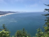
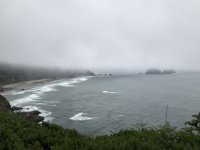
Yea....that's pretty. You caught the sun shining! I was in Tillamook and visited Cape Meares in summer of '18.
That is such a pretty area!
Cool article...looks like a lot of fun!Beautiful! I was right there about 14 months ago working on a project to translocate mountain goats from the Olympics to the Cascades; wrote this: https://window.wwu.edu/article/116853. Route 20, the N. Cascades Highway, is one of the most beautiful stretches of road in the world, I have to believe.
Those two capes are just incredible - and yes, we were there for a week and this was the one sunny day, lol - and because of COVID I had the place to myself!Yea....that's pretty. You caught the sun shining! I was in Tillamook and visited Cape Meares in summer of '18.
That is such a pretty area!
Here's a pic from Meares, too:
That is gorgeous!
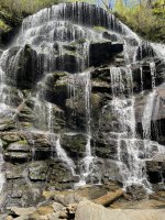
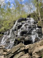
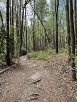
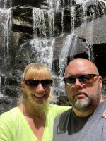
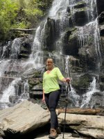
After having Covid back in December, it took me a while to get my breathing capacity back, and also gaining 20 pounds, I decided it was time to hit the trail again. I hadn't hiked since November, and was really missing it. So, the wife and I hiked to Yellow Branch falls in Walhalla. It was a moderate 3.5 miles, and it felt good to be out there again. It was one of the most beautiful falls I have ever seen.


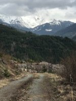
Biking, hiking and fishing are my go-to outdoors interests, but my knees at this point are so shredded from a long adult life of basketball and rugby that walking downhill (uphill is fine?) just hurts like hell, to the point where I hardly ever hike into the backcountry at all anymore. That said, There's a hike I do every spring and at the end of every summer because I love it and it's worth the pain - and I hiked it a few weeks back, and C&P's post reminded me that I took a pic or two. The peak in the background is the North Twin of the Sisters Range, seen from a different angle, closer and on a sunnier day, in Blitzy's "10,000 miles" thread.

That’s amazing! How long of a hike is it when you do this?Biking, hiking and fishing are my go-to outdoors interests, but my knees at this point are so shredded from a long adult life of basketball and rugby that walking downhill (uphill is fine?) just hurts like hell, to the point where I hardly ever hike into the backcountry at all anymore. That said, There's a hike I do every spring and at the end of every summer because I love it and it's worth the pain - and I hiked it a few weeks back, and C&P's post reminded me that I took a pic or two. The peak in the background is the North Twin of the Sisters Range, seen from a different angle, closer and on a sunnier day, in Blitzy's "10,000 miles" thread.
View attachment 2440
I had planned to do this on Saturday, but I had to meet a customer first. I wasn’t feeling it, and almost didn’t do it. However, within ten minutes of getting on the trail, I stopped and stood still for a few minutes and felt the calm of the woods settle over me. I don’t try to rush through a hike. I like to take it somewhat slow, and take in everything around me. I particularly enjoy crossing creeks, and this trail crossed four.
I understand about the injuries. My knees aren’t what they used to be, but I do ok. What I have to watch is my wife. She inherited a really bad ankle from her dad. His had to be completely reconstructed, and hers will too. She has really bad over pronation on her left ankle, and going downhill is bad for her because it makes it easier for her ankle to roll. But she loves it and she has good Merrell boots, and they help, but when going downhill, I make sure I’m ahead of her to catch her if it goes out. Fortunately, it hasn’t happened yet, but coming down sometimes freaks her out and I have to talk her down.
It's about 5 miles round trip or so? All climb to the top, rest and take in views, all descent back to the car. About a mile into the descent my knees have turned to mush ... but it's worth it! I don't know if you use or know about AllTrails.com, but it's free and lets you plot hikes and maps (and back-country bike rides too) really easily. Here's the Alltrails file for that hike:That’s amazing! How long of a hike is it when you do this?
https://www.alltrails.com/explore/trail/us/washington/blue-mountain-logging-road-south
Yes, I do. I have AllTrails Pro, and it’s fantastic! We like to hike to waterfalls, so I can look up the trail, and then download it before I leave home, and I can navigate, track speed, elevation and other stuff even if I have no cell reception, which is most of the time. I highly recommend it.It's about 5 miles round trip or so? All climb to the top, rest and take in views, all descent back to the car. About a mile into the descent my knees have turned to mush ... but it's worth it! I don't know if you use or know about AllTrails.com, but it's free and lets you plot hikes and maps (and back-country bike rides too) really easily. Here's the Alltrails file for that hike:
https://www.alltrails.com/explore/trail/us/washington/blue-mountain-logging-road-south
FurmanCock
Grand Poohbah
I strongly endorse AllTrails Pro also...lots of segment hikes on the AT done with the help of Pro.
awesome pics! If you want a cool experience, look up staying up at the top of Mt Leconte in one of the lodges...about a 5 mile hike up and they have about 10 cabins up there you can rent (no power lol) and they cook your dinner and breakfast and then you can hike back down the following morning. We went up last month and it was fantastic...I never get tired of the views
http://www.lecontelodge.com/
http://www.lecontelodge.com/

